GPS/Compass (landing page)
Copter/Plane/Rover support integration with GPS, Compass and other non-GPS positioning technologies. Sub supports only Compass, so some device below can only utilize the Compass portion of the hardware:
GPS/Compass
- ARK GPS
- ARK DAN GPS
- ARK SAM GPS
- ARK SAM GPS MINI
- ARK TESEO GPS
- Avionics Anonymous GNSS + Compass
- Avionics Anonymous Compass
- Beitain BN-220 GPS / BN-880 GPS + Compass Module
- CUAV Neo v2 Pro DroneCAN GPS
- CUAV Neo 3 Pro DroneCAN GPS
- CUAV Neo 3(M9N) GPS
- CUAV Neo 3X(Water proof) GPS
- CubePilot Here 2 DroneCAN GPS/Gyro/IMU/Baro
- Holybro DroneCAN M8/M9 GPS
- Holybro Micro M9N GPS Module
- Holybro Micro M10 GPS Module
- Holybro Nano Ublox M8 5883 GPS Module
- Holybro M8N (Pixhawk 4) GPS Module
- Holybro M9N GPS Module (UART)
- Holybro M9N GPS Module (DroneCAN)
- Holybro M10 GPS Module
- Holybro DroneCAN RM3100 Professional Grade Compass
- MakeFlyEasy POS3 DroneCAN GPS/Compass
- Matek DroneCAN GNSS M10-L4-3100
- Matek DroneCAN GNSS M9N-G4-3100
- Matek DroneCAN AP_Periph GNSS M10-L4-3100
- Matek SAM-M8Q
- Matek M8Q-CAN/DroneCAN GPS+Compass+Baro+Airspeed I2C port
- mRo GPS, GPS+Compass,RTK, and DroneCAN modules
- mRo Locaton One DroneCAN GPS/Compass
- Qiotek DroneCAN GNSS M10 QMC5883
- Qiotek GNSS M10 QMC5883
- Qiotek DroneCAN RM3100 Compass
- Teravolt AeroNav-1 GPS
- Zubax GNSS 2: GNSS + Compass + Barometer
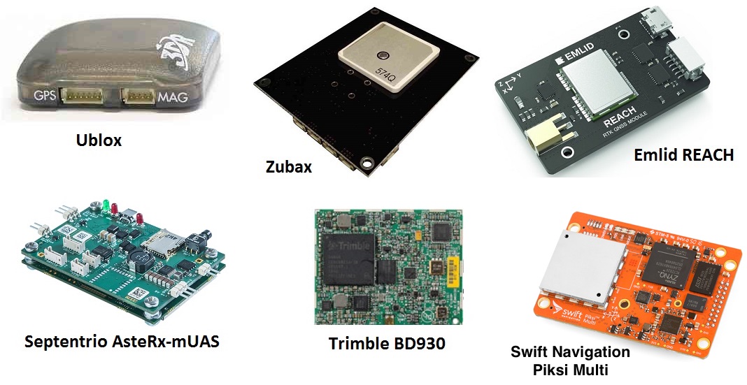
RTK GPS
These GPS can incorporate real time kinematic data, either internally generated or externally provided, to improve the precision of the position estimate from the normal GPS meter range down to the centimeter range (see RTK GPS Correction (Fixed Baseline)). This increased precision also allows for “Moving Baseline” yaw estimates using two devices on a vehicle with certain RTK GPSes (F9P based) or dedicated Moving Baseline GPSes. See GPS for Yaw (aka Moving Baseline).
- ArduSimple RTK GPS simpleRTK2B Budget (u-blox ZED-F9P)
- ArduSimple RTK GPS simpleRTK3B Pro (Septentrio Mosaic-X5)
- ArduSimple RTK GPS simpleRTK3B Compass (Unicore UM982, Dual antenna heading)
- ARK MOSAIC-X5 RTK GPS
- ARK RTK Base
- ARK RTK F9P
- ARK RTK GPS L1 L5
- ARK X20 RTK GPS
- Blicube RTK GPS (Single Unit Moving Baseline NMEA)
- CUAV C-RTK 9P RTK Receiver
- CUAV C-RTK 9Ps RTK Receiver
- CUAV C-RTK2 PPK and RTK receiver
- CUAV C-RTK2 HP Heading and RTK receiver
- DATAGNSS H10P RTK/Compass Receiver
- DATAGNSS GEM1305 RTK Receiver
- DATAGNSS NANO RTK Receiver
- Emlid Reach RTK Receiver
- CubePilot HERE 3/3+ DroneCAN RTK GPS/IMU/Compass
- CubePilot HERE 4 DroneCAN RTK GPS/IMU/Compass (see note below)
- CubePilot Here+ RTK Base/Rover Receiver
- CubePilot HEREPRO DroneCAN F9P RTK GPS/Compass
- Freefly RTK GPS Ground Station
- Foxteck AEROFOX F9P-RTK
- GNSS.Store UM980 ultraLight RTK GNSS Smart Antenna
- GNSS.Store ZED-X20P ultraLight RTK GNSS Smart Antenna
- GNSS.Store mosaic-X5 ultraLight RTK GNSS Smart Antenna
- GNSS.Store mosaic-g5 ultraLight RTK GNSS Smart Antenna
- Hitec PositionPro GNSS
- Holybro DroneCAN H-RTK F9P Rover
- Holybro DroneCAN H-RTK F9P Helical
- Holybro RTK F9P Family
- Holybro RTK M8P
- Holybro RTK F9P Ultralight
- Holybro RTK ZED-F9P Rover (RM3100 Compass, Barometer, IP66 Waterproof)
- Holybro RTK NEO-F9P Family
- Holybro RTK Unicore UM982 GPS (Dual Antenna Heading)
- Holybro RTK mosaic-H GPS (Dual Antenna Heading)
- LOCOSYS HAWK R1 RTK GNSS / R2 RTK GNSS + Compass
- Navisys GR-901U ZED-F9P RTK base for Ground Station
- Qiotek DroneCAN RTK-F9P GPS
- Swift Navigation's Piksi Multi RTK GPS Receiver
- Septentrio AsteRx-m UAS RTK GPS
- Synerx MDU-2000 RTK + LTE GPS
- Trimble BD930 RTK GNSS
- Trimble PX-1 RTX GNSS+INS
Note
a version of firmware for the CubePilot HERE 4 DroneCAN RTK GPS is available here that includes evolving ArduPilot improvements.
Warning
It is important that a GPS be connected to the first SERIALx port that has its SERIALx_PROTOCOL parameter set to “5” (GPS) since it will stop searching for GPS during boot-up if not found on the first port configured for GPS protocol.
Moving Baseline (GPS for Yaw) Capable
- Ark RTK GPS <https://arkelectron.com/product/ark-rtk-gps/> Blicube RTK GPS (Single Unit Moving Baseline)
- CUAV C-RTK 9P RTK Receiver
- CUAV C-RTK 9Ps RTK Receiver
- CUAV C-RTK2 PPK and RTK receiver
- CUAV C-RTK2 HP Heading and RTK receiver
- CubePilot HERE 4 DroneCAN RTK GPS/IMU/Compass
- CubePilot HEREPRO DroneCAN RTK GPS/Compass
- Foxteck AEROFOX F9P-RTK
- Freefly RTK GPS Ground Station
- Holybro DroneCAN H-RTK F9P Rover
- Holybro DroneCAN H-RTK F9P Helical
- Holybro RTK F9P Family
- Holybro RTK F9P Ultralight
- Holybro RTK ZED-F9P Rover (RM3100 Compass, Barometer, IP66 Waterproof)
- Holybro RTK NEO-F9P Family
- Holybro RTK Unicore UM982 GPS (Dual Antenna Heading)
- Holybro RTK mosaic-H GPS (Dual Antenna Heading)
- Qiotek DroneCAN RTK-F9P GPS
- Synerx MDU-2000 RTK + LTE GPS
GPS Auto Configuration
The GPS_AUTO_CONFIG parameter provides several automatic configuration options.
- 0: Disable automatic configuration
Not recommended when using supported hardware.
- 1: Enable automatic configuration for Serial GPSes only
Default value; supports many common modules.
- 2: Enable automatic configuration for DroneCAN as well
Intended for use when configuring DroneCAN GPS modules for GPS for Yaw (aka Moving Baseline) operation.
Note
After selecting option 2 for GPS for Yaw (aka Moving Baseline) configuration, reverting to default (non-moving-baseline) operation requires connecting to the DroneCAN peripheral(s) and manually restoring the internal GPSx_TYPE parameters to their default values.
- 3: Clear all configurations not set by ArduPilot (u-Blox only)
On next boot, resets u-Blox GPS modules to default before applying ArduPilot configuration values (u-Blox Generation 9 and newer).
GPS Driver Options
Several GPS operating options are provided by the GPS_DRV_OPTIONS parameter. This parameter is a bit mask and allows multiple option selections at the same time:
bit 0: if set, will send RTK correction data from the first GPS directly to the second via the second’s UART port for GPS for Yaw (aka Moving Baseline), instead via the autopilot.
bit 1: if set, enable SBF moving baseline yaw using custom base and GPS_MB1 offsets.
bit 2: if set, use 115.2Kbaud for max serial data rate for those GPSes not capable of higher rates.
bit 3: if set, routes RTK data between two CAN GPSes via CAN instead of via the autopilot.
bit 4: if set, GPS reports altitude in ellipsoid height instead of height AMSL.
bit 5: if set, GPS satellite health is reported solely from L1 band (overriding L5 band health).
bit 6: if set, always enable RTCM decoding (even for single channel RTCM).
bit 7: if set, always disable RTCM decoding (even when RTCM is seen on more than one channel).
bit 8: if set, force u-Blox Config Get/Set (serial connected u-Blox Generation 9 and newer).
GPS Auto Switch
When using two GPS units there are a number of switching options that can be selected with GPS_AUTO_SWITCH.
- 0: Use Primary
Always use the primary GPS, this can be either the first or second as set with GPS_PRIMARY
- 1: Use best
Automatically select the best GPS, this is done based on GPS fix status (2D / 3D / rtk) if both GPSs have the same fix status the one with the larger number of satellites is used.
- 2: Blend
Blend is best suited for use with two identical GPS units, see GPS blending
- 4: Use primary if 3D fix or better
Use primary GPS as set with GPS_PRIMARY if it has a 3D fix or better. This should be used when two dissimilar GPS units are used, one high quality primary unit, and a secondary less accurate unit. In this case the high quality GPS will often have a better quality fix even if it has fewer satellites. Using ‘Use best’ in this case would result in using the poorer quality GPS and result in more switching between GPS units. Unlike ‘Use Primary’ this option still allows falling back to the secondary GPS if 3D fix is lost on the primary.
An additional variation with GPS switching is EKF3 affinity and lane switching. An EKF lane can be setup to use either GPS and the whole EKF lane is then switched based on its health. If the GPS_PRIMARY is used for a lane, and GPS_AUTO_SWITCH is enabled, then the lane will use GPS info as determined by the GPS_AUTO_SWITCH setting.
GPS Jamming Mediation
Setting the “JammingExpected”, EK3_OPTIONS bit 0, will change the EKF3 behaviour such that if dead reckoning navigation is possible it will require the preflight alignment GPS quality checks controlled by EK3_GPS_CHECK and EK3_CHECK_SCALE to pass again before resuming GPS use if GPS lock is lost for more than 2 seconds (presumably due to jamming). This is to prevent bad GPS data from being used, since the GPS data will be immediately used upon re-lock otherwise and could be corrupt.